
GNSS Station OL01
The OL01 station, located near ‘Cluster A’ of the Cornegliano Laudense plant, houses both the seismic station and the GNSS station. GNSS instrumentation is intended to monitor the ground deformation at the surface and eventually indicate potential anomalous phenomena. The installation of the GNSS station was completed on 27/10/2016. The station can receive signals from the following satellite navigation systems: GPS, GLONASS, GALILEO, QZSS, SBAS and BeiDou.
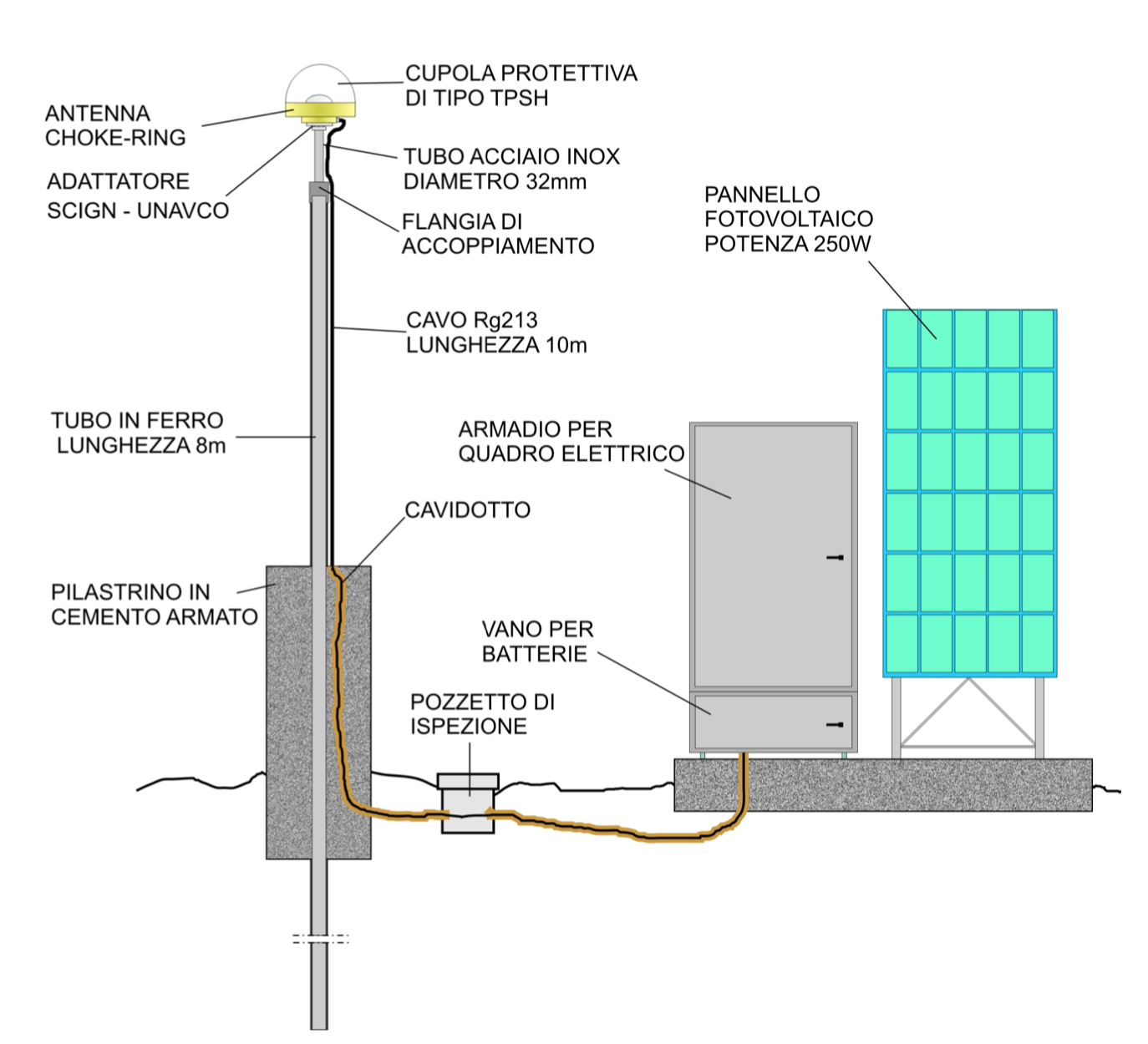
Construction scheme of the OL01 GNSS station
- Antenna choke-ring
- Adattatore SCIGN – UNAVCO
- Cupola protettiva di tipo TPSH
- Tubo acciaio inox, diametro 32 mm
- Flangia di accoppiamento
- Cavo Rg213, lunghezza 10 m
- Tubo in ferro, lunghezza 8 m
- Pilastrino in cemento armato
- Cavidotto
- Pozzetto di ispezione
- Armadio per quadro elettrico
- Vano per batterie
- Pannello fotovoltaico, potenza 250 W
The monumentation of the GNSS OL01 station consists of the following components:
- An iron pipe with a diameter of approximately 89 mm is cemented in the tube to ground cavity; therefore, the pillar, whose base is approximately 30 cm below the ground, is in continuity with the concrete/iron micropile 6 m below. The iron pipe is coupled with a terminal consisting of a flange and a stainless-steel pipe with a diameter of 32 mm and a total length of approximately 350 mm;
- The stainless-steel terminal, through the SCIGN Mount adapter (as per GNSS installation directives dictated by the UNAVCO protocol) is coupled the GNSS antenna (Topcon TPSCR.G5 TPSH) that can receive the signals from the various GPS constellations: GLONASS, etc.;
- The antenna is connected to the Topcon NET-G5 GNSS receiver, which records all the information received from the GNSS antenna;
- The receiver is housed inside a cabinet where the electrical panel that performs the following functions is located:
- power supply through a voltage regulator (WRM-15 MPPT charge regulator) connected to a 250 Watt photovoltaic panel and two 100 Ah batteries;
- data transmission via a UMTS router (UR5i v2);
- LAN controller 2.0 (Soft. Version 3.11) for monitoring and restoring the GNSS station and the instrumentation contained within the electrical panel.
Inside the electrical panel, there is also an ethernet switch and a timer. The data collected (RINEX files) are sent through the UMTS router for a subsequent processing phase to the OGS frednet server located at the Seismological Research Centre of Udine.
GNSS data processing
The OL01 station records, with 1 second sampling, the data coming from the satellites belonging to the GNSS (Global Navigational Satellite System) that orbit the Earth.
GNSS Station OL01 - Geodetic survey
The OL01 station dataset, recorded in RINEX format files, is available in daily sessions and with 30-second sampling (2880 daily observations). There are 743 RINEX files registered through 31/05/2019. Data processing has produced 683 solutions or 91.9% of the initial data. This indicates the availability of a formally correct dataset suitable for processing with the GAMIT/GLOBK package.
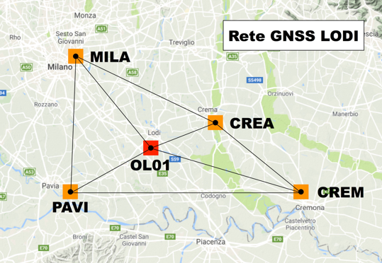
The GNSS OL01 station has been framed within a network of permanent stations called the Lodi GNSS network (Figure 2) using the following 4 stations belonging to the SPIN Network:
- CREA (Crema), baseline equal to 18.6 km;
- CREM (Cremona), baseline equal to 45.1 km;
- MILA (Milan), baseline equal to 27.9 km;
- PAVI (Pavia), baseline equal to 27.6 km.
These stations are in turn framed in the ETRF2000 (2008.0) system with the coordinates provided by SPIN GNSS according to the National Dynamic Network managed by the Military Geographic Institute. The result of framing the OL01 station is shown in Table 1.
| Site code | Località | Ricevitore | Antenna | Lat | Lon | Quota [m] |
|---|---|---|---|---|---|---|
| PAVI | Pavia | TPS NET-G5 (GPS+GLO) | TPSCR3_GGD CONE | 45°12'10,73212"N | 9°08'10,10393"E | 143,636 |
| MILA | Milano | TPS NET-G3 (GPS+GLO) | TPSCR3_GGD CONE | 45°28'47,94818"N | 9°13'45,62699"E | 187,275 |
| CREM | Cremona | TPS ODYSSEY_E (GPS+GLO) | TPSCR3_GGD CONE | 45°08'47,92729"N | 10°00'07,02572"E | 102,736 |
| CREA | Crema | TPS ODYSSEY_E (GPS+GLO) | TPSCR3_GGD CONE | 45°21'15,59235"N | 9°41'07,09675"E | 129,818 |
| OL01 | Cornegliano Laudense | TPS NET-G5 (GPS+GLO) | CR-G5 (TPSH) | 45°17'28,17435"N | 9°27'53,47318"E | 121,254 |